Question 1:
In which of the following stages of landform development, downward cutting is dominated?
- Youth stage
- Late mature stage
- Early mature stage
- Old stage
Answer:
(a). Youth stage
Question 2:
A deep valley characterised by steep step-like side slopes is known as:
- U-shaped valley
- Gorge
- Blind valley
- Canyon
Answer:
(c). Canyon
Question 3:
In which one of the following regions the chemical weathering process is more dominant than the mechanical process?
- Humid region
- Limestone region
- Arid region
- Glacier region
Answer:
(a). Humid region
Question 4:
Which one of the following sentences best defines the term ‘Lapies’?
- A small to medium sized shallow depression
- A landform whose opening is more or less circular at the top and funnel shaped towords bottom.
- A landform formed due to dripping water from surface.
- An irregular surface with sharp Pinnacles grooves and ridges.
Answer:
An irregular surface with sharp Pinnacles grooves and ridges.
Question 5:
A deep, long, and wide trough or basin with very steep concave high walls at its head as well as in sides is known as:
- Humid region
- Limestone region
- Arid region
- Glacier region
Answer:
(a). Humid region
Question 6:
Which one of the following sentences best defines the term ‘Lapies’?
- A small to medium sized shallow depression
- A landform whose opening is more or less circular at the top and funnel shaped towords bottom.
- A landform formed due to dripping water from surface.
- An irregular surface with sharp Pinnacles grooves and ridges.
Answer:
(c). An irregular surface with sharp Pinnacles grooves and ridges.
Question 7:
A deep, long, and wide trough or basin with very steep concave high walls at its head as well as in sides is known as:
- Cirque
- Lateral moraine
- Glacial valley
- Esker
Answer:
(a). Cirque
Question 8:
What do incised meanders in rocks and meanders in plains of alluvium indicate?
Answer:
It is common to find meanders over flood plains and deltas. But very deep or incised meanders can also be found cut in rocks. These show lateral erosion. Meanders develop in the from of loops. Some loop get entrenched due to continued uplift and down cutting. Over time, these form deep gorges and canyons in hard rocks.
Question 9:
Explain the evolution of valley sinks or uvalas.
Answer:
Valley sinks. Sink-holes are small depressions, formed by solution. These are funnel-shaped. The rain water sinks into these sink-holes. These are known as dolines or swallow holes. Some streams, all of a sudden disappear underground, through swallow holes. Several dolines merge together to form a large depression known as uvala.
Question 10:
Underground flow of water is more common than surface run off in limestone areas. Why?
Answer:
In Karst regions, there is a general absence of surface drainage. Most of the surface water goes underground. Streams flow only for short distances over limestone areas. Then, these disappear underground. Dry valleys are formed on the surface. Streams develop a system of underground channels, called blind valleys. These streams reappear on the surface after some distance.
Question 11:
Glacial valleys show up many linear depositional forms. Give their locations and names.
Answer:
Clay and drift are deposited by glaciers after melting. These hillocks are called moraines. The material deposited on the two sides of the glacier is called lateral moraine. Two lateral moraines meet to form medial morianes. Surface moraines are found on the top of glacier. Terminal moraines are found at the end of glacier.
Question 12:
How does wind perform its task in desert
regions ? Is it the only agent responsible for
the erosional features in desert regions?
Or
Describe the work of wind as an agent of
erosion, transportation and deposition.
Answer:
Work of Wind : Wind is an important agentof change in arid regions of the world. Its work is limited to deserts due to absence of vegetation and low rainfall. It creates an arid or aeolian topography.
EROSION. Wind erosion is performed in these ways :
(i) Under-cutting.
(ii) Gully erosion.
(iii) Scratching.
(iv) Polishing.
Types of Wind Erosion:
Wind erosion is mainly of three types :
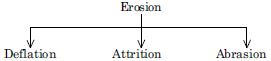
(a) Deflation. Deflation is the complete lifting and blowing away of fine dust from the ground. It results in formation of depressions and soil erosion.
Examples : (i) Petrie has estimated that at least a layer of 2.5 metres has been removed by the wind from the Nile Delta in 2600 years.
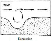
(ii) Blow outs (Depressions). Large depressions, known as blow outs, are formed by deflation. The Qattara depression in Egypt lies almost 143 metres below sea level.
(b) Abrasion. Abrasion is the work of strong air armed with sand and dust particles which are the tools of wind. It drives them with force against the rocks. Rocks are polished and smoothed. A wind acts like a sand blast.
(c) Attrition. Sometimes pieces of wind-blown material collide into each other. It is greatly reduced and grains are formed. This action is called Attrition.
Landforms of Wind Erosion:
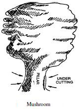
1. Mushroom. Under-cutting by wind is maximum at the base of the rocks. It produces thin pillars at the base due to erosion of soft rocks. Hard rocks are left upstanding on these pillars. Hollows are cut in the rock’s surface so that the total picture resembles a mushroom.
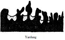
2. Yardangs. When hard and soft rocks are arranged vertically, sharp-pointed, steep-sided, overhanging ridges of hard rocks are formed. These are called Yardangs. They are roughly parallel and run in the direction of the prevailing wind. These resemble ribs of a skeleton. These are generally 15 metres high and are found in the deserts of Central Asia.
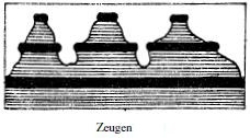
3. Zeugens. These are formed when soft rocks lie under the layer of hard rocks. Soft rocks are eroded and deep furrows are formed. The flat-topped hard rocks overhang soft rocks. These are called zeugens. These resemble an inkpot with a cap.
4. Bridges and Windows. Sometimes big openings are formed in hard rocks. After a long time, across a hill, windows are formed. These are arch-shaped like Hope window in the U.S.A.
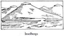
5. Inselberg. Inselbergs are residual hills rising abruptly from the ground. These are composed of hard rocks like granite and gneiss. These have steep slope and rounded tops. They look like dome-shaped pyramids. ‘Inselberg’ is a German word meaning ‘Island mountain’. These are mostly found in Kalahari Desert.
DEPOSITION
When the velocity of wind decreases, it starts depositing its load. Sand dunes and loess deposits are formed due to wind deposition.
Sand Dunes. Sand dunes are hills of wind-blown sand. These are found in areas like :
(i) sandy coasts.
(ii) in deserts.
(iii) on the sandy-shores of lakes.
(iv) along river banks.
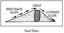
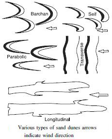
Types of sand dunes :
Sand dunes are of three major types :
(i) Longitudinal dunes. These are long narrow ridges of sand. These lie parallel to the direction of the prevailing wind. They are sometimes 100 metres high. These are called Seif (meaning sword) in Sahara.
(ii) Transverse dunes. These are formed perpendicular to the wind. They look like large waves of sand. They are semi-circular in shape.
(iii) Barchans. Barchan is a crescent or moon shaped sand dune formed in a perpendicular direction to the wind. The windward side is convex and gentle while the leeward side is concave and steep. Its ends are called Horns.
These resemble a Sickle or Bow. The sand dunes keep on advancing and many towns and buildings have been buried under these sand dunes.
(iv) Loess. Loess is a wind-borne deposit. It is a yellow, porous, fertile deposit. The most extensive deposits are found in the N. W. China in Hwang-Ho- Basin. It covers an area of 3 lakh sq. miles. Actually the word ‘loess’ comes from such a deposit in a village of France.
Question 13:
Limestones behave differently in humid
and arid climates. Why ? What is the dominant
and almost exclusive geomorphic process in
limestone areas and what are its results?
Or
Describe the work of underground water in
Karst regions
Answer:
Work of Glacier. Glacier like other agents,
plays a combined role of erosion, transportation and
deposition throughout its course. On mountain slopes
and valleys, its work is mainly erosion; on plateaus its
work is mostly protective; on lowlands, its work is
deposition.
Erosion. A glacier performs its erosion by different
actions like :
(i) Plucking.
(ii) Grooving.
(iii) Abrasion.
(iv) Grinding.
(v) Polishing.
A glacier plucks big pieces of rocks from the
underlying rocks. Big hollows are formed on the valley
floor. The glacier collects big pieces of rocks from
avalanches and landslides. These fragments are the
powerful tools of glacier. The glacier scratches, polishes
the rock surfaces and grinds the pebbles and stones at
its bottom. In this way, mountains are rounded and
valleys are deepened and widened. The general rugged
highland area becomes smooth.
The glacier erosion depends upon the following
factors :
(i) Amount of Ice.
(ii) Nature of the rocks.
(iii) Movement of glaciers.
(iv) Slope of the land.
Landforms, formed by Erosion :
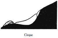
1. Cirque. Cirques are semi-circular hollows at the
side of a mountain. The moving ice produces depressions
on the slopes of the mountain. Plucking and frost wedging
deepens and widens these depressions. An armchairshaped
basin with a back wall is formed. These are
known as cirques in France, corries in Scotland,
cwms in Wales and karrens in Germany. After the
melting of ice, a Tarn like is formed in these cirques.
2. Horns. Sometimes several cirques are formed
on all sides of a mountain. These cirques cut back
together until these almost meet. A horn-shaped
pyramid is formed. This sharp pointed peak is known
as Horn. The Matter Horn of Switzerland is a classic
example.
3. Col. Col is a saddle shaped pass through
mountains. When on the opposite sides of a ridge, two
cirques meet, a col is formed.
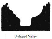
4. U-shaped Valley. When a glacier enters a
V-shaped valley, it changes its shape. The glacier widens
and deepens the valley. A V-shaped valley thus becomes
a U-shaped valley. A U-shaped valley has a wide flat
floor and steep sides. St. Lawrence valley of North
America is a U-shaped valley. Drowned glaciated valleys
are known as fiords; as along the coast of Norway.
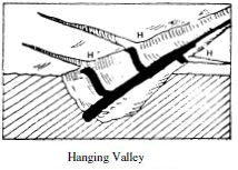
5. Hanging Valley. A hanging valley is formed by a
tributary glacier. The main glacier forms a much deeper
valley than a tributary glacier. After the ice has melted,
the tributary valley is left at a higher level than the
main valley. Such valleys appear hanging above the main
valley and are called hanging valleys.
Transportation. Glacier carries different types of
material (load). This material comes from avalanches,
great heights, valley floor and walls.
The glacier transports boulders, clay, till, drift, gravel,
sand, etc. These materials are transported in different
ways :
(i) dragged under the bottom of the glacier.
(ii) carried on the surface of the glacier.
(iii) collected in the layers of the ice.
Deposition. When a glacier melts, it is called
the retreat of a glacier. Most of the material brought
by glacier is deposited. These deposits are called Till or
Drift. Glacier deposits its material in the form of hillocks.
These are known as moraines. According to the place of
deposition, moraines are of the following four types :
(i) Lateral Moraines. The material deposited on
the two sides of the glacier is called a Lateral or Marginal
Moraine. It is a ridge of loose and broken material,
rising to a height of 100 feet.
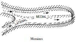
(ii) Medial Moraines. These are formed by the
meeting of two glaciers. When two glaciers meet at a
point, the inner lateral moraines unite to form only one
ridge. This ridge along the middle of the main
glacier is called a medial moraine.
(iii) Terminal Moraines. When the glacier melts,
some material is left behind at the Snout of the
glacier. This is called End moraine or Terminal
moraine.
(iv) Ground Moraines. The material deposited
underneath a glacier is called a ground moraine. These
are found scattered on valley floor.
(v) Other Landforms. After the melting of the
glacier, many streams flow from the end of the glacier.
These streams deposit sand and gravel in different
layers to form an outwash plain; kettle lakes are formed
by filling of depressions with water. Oval shaped
deposits like an inverted boat are formed and known
as Drumlins. These deposits appear like eggs in a
basket. Long narrow ridges called eskars and small
rounded hillocks called kames are formed at the end
of the glacier.