Question 1:
Which one of the following rivers was known as the ‘Sorrow of Bengal’?
- The Gandak
- The Son
- The Kosi
- The Damodar
Answer:
(d). The Damodar
Question 2:
Which one of the following rivers has the largest river basin in India?
- The Indus
- The Brahmaputra
- The Ganga
- The Krishna
Answer:
(c). The Ganga
Question 3:
Which one of the following rivers not included in ‘Panchnad’?
- The Ravi
- The Chenab
- The Indus
- The Jhelum
Answer:
(c). The Indus
Question 4:
Which one of the following river flows in a rift valley?
- The Son
- The Narmada
- The Yamuna
- The Luni
Answer:
(b). The Narmada
Question 5:
Which one of the following is the place of confluence of the Alkananda and the Bhagirathi?
- Vishnu Prayag
- Rudra Prayag
- Karan Prayag
- Dev Prayag
Answer:
(d). Dev Prayag
Question 6:
Distinguish between: River Basin and Watershed.
Answer:
River Basin.
When a big river gets water
flow from a specific area, and falls into sea. Many
tributaries also join it. This region is called River
Basin.
Watershed.
The area drained by small rivers is
called watershed. It is smaller than a River Basin.
Question 7:
Distinguish between: Dendritic pattern and Trellis pattern of drainage.
Answer:
Dendritic pattern. This pattern is similar to the branches of a tree. The river of northern plain makes a dendritic pattern similar to a tree. Trellis pattern. When the main rivers flow parallel to one another and the tributaries join these at right angles, it is called a trellis pattern.
Question 8:
Distinguish between: Radial and Centripetal drainage pattern.
Answer:
Radial Drainage. When rivers radiate from a highland and how in all the directions, it is called a radial system. The rivers originating from Amarkantak Hills are an example of radial pattern. Centripetal pattern. When streams from all the directions flow into a lake or a depression, it is called a centripetal pattern. For example the drainage in Thar Desert.
Question 9:
Distinguish between: A delta and an Estuary.
Answer:
Delta. A delta is a triangular (Δ) landmass deposited by sediments of river on the mouth of a river. Ganga-Brahmaputra is the largest delta of the world. Estuary. When the slope is steep in the lower section of a river, it does not deposit sediment. Sediments are washed away into sea. A narrow channel is formed for example by Narmada river.
Question 10:
What are the socio-economic advantages of linking the rivers in India?
Answer:
The Himalayan rivers are different from Peninsular rivers. Vindhya-Satpuras act as a waterdivide. The rivers of northern plains have excess of water, while Peninsular rivers are seasonal rivers. These rivers can be linked by Ganga-Kaveri scheme. The excess water of northern rivers can be put into the rivers deficient in water. It will help to extend irrigation. It will solve the problem of drought. It will increase the production of Hydro electricity and foodgrains.
Question 11:
Write three characteristics of Peninsular river.
Answer:
(a) These rivers are short in length and few in number.
(b) These are seasonal rivers having water in rainy season.
(c) These are not suitable for navigation and irrigation.
Question 12:
What are the important characteristic features of North Indian rivers? How are these different from Peninsular rivers?
Answer:
Drainage Systems of India
Drainage system of an area depends upon its relief
and slope. Rivers have played a vital role in the
development of religious and social history of India.
India’s agricultural economy depends upon rivers.
India has been often called a ‘land of rivers’. Vindhyas
act as a water divide between the rivers of Northern
India and the Peninsular India.
(A) Drainage System of Northern India
Most of the rivers of the Northern India originate
from the Himalayas. These are perennial rivers as
these are snow-fed rivers. Many rivers belong to the
antecedent drainage system. The northern plain has
been formed by the deposition of sediments brought
down by these rivers. This drainage system extends
from Punjab to Assam and is divided into three
systems :
(i) The Indus system
(ii) The Ganges system
(iii) The Brahmaputra system.
1. The Indus Drainage System. It is one of the
world’s largest systems. It comprises the rivers of the
Indus, the Jhelum, the Chenab, the Ravi, the Sutlej
and the Beas. The Indus, the Jhelum and the Chenab,
flow in Pakistan.
(i) The Sutlej. It originates from Rakshas Tal near
Mansarovar lake across the Himalayas. It forms a deep
gorge. It is 1050 km. long and feeds the Bhakra canal.
(ii) The Beas. It originates from the Beas Kund
near Rohtang Pass. It is 470 km. long. It lies within
the boundaries of Punjab State.
(iii) The Ravi. The Ravi rises in Dhauladhar Hills.
It enters the plains near Madhopur. It is 720 km. long
and forms a natural divide between India and
Pakistan.
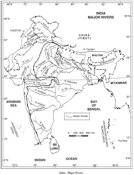
2. The Ganges Drainage System
(i) The Ganges : The Ganges is the most sacred
river of India. The story of the Ganges from her source
to the sea, from old times to new is the story of India’s
civilisation and culture. The Ganges has its source near
Gomukh glacier, near Gangotri. The Ganges is formed
by two head streams namely Alaknanda and
Bhagirathi. It enters the plains near Haridwar. The
Yamuna meets this river at ‘Sangam’ at Prayagraj. The
Ganges is the Master stream of the area. South of
Farakka, the river divides into a number of channels to
form ‘Sunderban’ Delta. The Ramganga, Ghaghra,
Gandak, Baghmari join the Ganges from its left. The
Yamuna and the Son join it from the South. It is 2071
km. long. Haridwar, Kanpur, Prayagraj, Varanasi,
Patna and Calcutta (Kolkata) are situated along the
Ganga.
(ii) The Yamuna : It is the most important tributary
of the Ganga. It is 1300 km. long. It rises from the
Yamnotri Glacier. The Chambal, Betwa and Ken rivers
join the Yamuna from the south.
(iii) The Kosi : The Kosi emerges from the great
Himalayas. It flows for 730 km. in Nepal and India. It is
known for its notorious floods and called ‘River of sorrow’.
3. The Brahmaputra System. The Brahmaputra
river is the master stream of this system. It is 2900 km.
long. It flows parallel to the Himalayas in Tibet and is
known as Tsangpo. It enters India in Arunachal Pradesh
through Dihang gorge. It is known for its notorious floods
and silt deposits. It joins Padma river in Bangladesh to
form a large delta.
(B) The Drainage System of Peninsular India
Most of the Peninsular rivers are seasonal. These
flow through narrow, deep valleys. These rivers can be
divided into two categories :
(i) Rivers falling into the Arabian Sea.
(ii) Rivers falling into the Bay of Bengal.
Question 13:
Drainage System
Answer:
Suppose your are travelling from Haridwar to
Siliguri along the foothills of Himalayas are Ganga, Sarda
River, Gomati River, Ghagara River, Gandak River,
Kosi River.
Importance of River Ganga. The Ganga is the
most sacred river of India. Ritual bathing in the River
was an important part of Hindu pilgrimage when this
river floods, rich alluvial deposits replenish the soil and
produce ideal compound. This river is also useful
transportation, fishing and hydroelectric energy.