Question 1:
Upward and downward movement of ocean water is known as the:
- Tide
- Current
- Wave
- None of the above
Answer:
(a). Tide
Question 2:
Spring tides are caused:
- As result of the moon and the sun pulling the earth gravitationally in the same direction.
- As result of the moon and the sun pulling the earth gravitationally in the opposite direction.
- Indention in the coast line.
- None of the above.
Answer:
(a). As result of the moon and the sun pulling the earth gravitationally in the same direction.
Question 3:
The distance between the earth and the moon is minimum when the moon is in:
- Gold
- Perigee
- Perihelion
- Apogee
Answer:
(d). Apogee
Question 4:
Which one of the following is the hardest mineral?
- Topaz
- Diamond
- Quartz
- Feldspar
Answer:
(a). Feldspar
Question 5:
The earth reaches its perihelion in:
- October
- September
- July
- January
Answer:
(d). January
Question 6:
What do you mean by rocks? Name the three major classes of rocks.
Answer:
Any natural, solid inorganic or organic material out of which the crust is formed is
called a rock. It may be hard as granite or soft as clay. Clay, chalk, coal, gravel,
etc. are examples of rocks. Lithosphere is made up of rocks. On the basis of their mode
of formation, rocks are divided into three types :
(a) Igneous rocks
(b) Sedimentary rocks
(c) Mentamorphic rocks.
Question 7:
What are waves?
Answer:
Waves are the to and fro movements with a swaying motion. These take place due to the movement of winds on the surface of the ocean water. Waves are actually the energy which moves across the ocean surface.
Question 8:
Where do waves in the ocean get their energy from?
Answer:
Wind provides energy to the waves. This causes waves to travel in the ocean and the energy is released on the shoreline. Waves continue to grow larger as they move and absorb energy from the wind.
Question 9:
What are tides?
Answer:
The periodical rise and fall of the sea level, once or twice a day, mainly due to the attraction of the sun and the moon, is called a tide.
Question 10:
How are tides caused?
Answer:
Tides are caused due to the following :
(a) The moon’s gravitational pull
(b) The sun’s gravitational pull
(c) Centrifugal force, which is the force that acts to
counter balance the gravity.
Together, the gravitational pull and the centrifugal
force are responsible for creating the two major tidal
bulges on the earth.
Question 11:
How are tides related to navigation?
Answer:
Tidal flows are of great importance in navigation. Tidal heights are very important, especially harbours near rivers and within estuaries having shallow ‘bars’ at the entrance, which prevent ships and boats from entering into the harbour.
Question 12:
How do currents affect the temperature? How does it affect the temperature of coastal areas in N.W. Europe?
Answer:
Effects of Ocean Currents. Ocean currents
exert a powerful influence on the environment of the
areas where they flow.
(a) Effects on Climate. Ocean currents have
indirect influence on the climate of coastal areas.
These affect the temperature, rainfall and the general
weather of the adjoining areas.
(i) Temperature. The warm currents raise and
the cold currents lower the temperature of the
neighbouring lands. The winds blowing over the cold
currents carry low temperature and have a cooling
effect. Wind blowing over warm currents have a
warming effect and raise the winter temperature of
regions situated in higher latitudes. The Labrador
coast remains icebound due to the cold Labrador
current but the coast of North-West Europe, though
in the same latitude remains open due to warm Gulf
stream current but the coast of North-West Europe,
though in the same latitude. North-West Europe has
an ideal climate due to the moderating effect of North-
Atlantic drift.
(ii) Rainfall. The winds blowing over warm
current absorb more moisture and give more rainfall.
The winds blowing over cold currents are cold and
cannot absorb much moisture. North-West Europe
gets heavy rainfall due to Gulf stream current. Cold
currents flow along the west coasts of the continents
within the tropics and deserts are found on these
coasts such as Kalahari, Atacama etc.
(iii) Fog. Dense fog is produced due to the
meeting of warm and cold currents. The Warm
moisture is condensed and results in the formation
of fog. Fog is produced near Newfoundland due to
the meeting of cold Labrador current and the warm
Gulf stream current. Visibility is also reduced due
to fog.
(b) Effect on Trade :
(i) Open harbours. In high latitudes, harbours
remain open all the year round due to the influence
of warm currents. The coast of Norway and Great
Britain remain unfrozen due to warm Gulf stream
current. But the ports of Eastern Siberia like
Vladivostok are icebound due to cold kurile current.
(ii) Ocean routes. Currents determine ocean
routes. Ships follow routes avoiding icebergs.
Icebergs floating along with cold currents (Such as
with Labrador currents) are a danger to shipping.
(iii)Navigation. The velocity of ships was
greatly influenced in the days of sailing ships by
backing currents or facing currents. But currents
have not so important effect on modern steam ships.
(iv) Effect on marine life. Ocean currents
encourage the growth of plankton which is the food
for fish and other marine life. The fish travel along
with currents. Great fishing banks are found along
the coast of Japan and Newfoundland because cold
and warm currents meet here.
Question 13:
What are the causes of currents?
Answer:
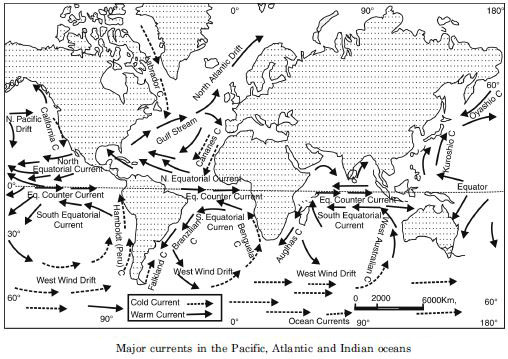
Ocean currents. Regular movements of water
from one part of the ocean to another is called an ocean
current. An ocean current is like a river in the ocean.
There is actual movement of water in a current.
Causes of the origin of ocean currents.
Following are the chief causes of the origin of the ocean
currents :
1. Prevailing Winds. Ocean currents are primarily
wind determined. Currents follow the main direction of
the planetary winds.
The Trades and the Westerlies blow in same
direction throughout the year. In tropical areas,
Equatorial currents move along with Trade winds from
east to west. In temperate latitudes Westerlies drive
the water of Gulf Stream to western coast of Europe
as North Atlantic drift. The direction of the current
changes in summer and winter according to the
direction of monsoon winds.
2. Difference in Temperature. Warm water is
lighter and rises but the cold water is denser and
sinks. This makes a difference in the level of sea.
Warm equatorial water moves poleward along the
surface, while the cold polar water moves along the
bottom towards the equator as ocean currents.
3. Difference in Salinity. Waters of high salinity
are denser and heavier, while the waters of low salinity
are lighter. The fresh water floats on the surface, while
waters of high salinity flow at the bottom of the ocean.
Lighter surface water from the Atlantic flows into the
Mediterranean while an under-current of denser water
flows towards the Atlantic from Mediterranean Sea.
4. Evaporation and Rainfall. Evaporation makes
the water more saline and dense. Due to heavy rainfall
the surface of the sea water rises. Consequently, ocean
currents flow from higher level to lower level of water
in the ocean.
5. Rotation. The rotation of the earth changes the
direction of currents to assure a circular direction. The
ocean currents in the northern hemisphere are deflected
to their right and in southern hemisphere to their left.
Thus according to Ferral’s law, currents have a clockwise
circulation in the northern hemisphere and anticlockwise
circulation in the southern hemisphere.
6. The Shape of Coast. The shape of the coast
obstructs and diverts ocean currents. For example, the
Cape Sao Reque of Brazil diverts the South Equatorial
Current as Brazilian current.