Boost your exam preparation with NCERT Solutions available at Aasoka for free. Aasoka is a top online learning platform that provides the finest educational resources to students of all classes. Students will find the NCERT Solutions for Class 10th Geography very beneficial as they are designed as per their requirements. They serve as a perfect way, for students, to do their revision thoroughly before appearing for their board exams.
“Lifelines of National Economy” chapter of Geography explains the various means of transportation such as waterways, airways, pipelines, roadways, seaports, and railways. Students will learn how transportation and communication have contributed to the growth of the Indian Economy. There is also a mention of International Trade, means of communication in India, and Tourism as Trade.
Question 1:
Which two of the following extreme locations are connected by the East-West Corridor?
- Mumbai and Nagpur
- Silchar and Porbandar
- Mumbai and Kolkata
- Nagpur and Siliguri
Answer:
(b) Silchar and Porbandar
Question 2:
Which mode of transportation reduces trans-shipment losses and delays?
- Railways
- Roadways
- Pipeline
- Waterways
Answer:
(c) Pipeline
Question 3:
Which one of the following states is not connected by the HVJ pipeline?
- Madhya Pradesh
- Maharashtra
- Gujarat
- Uttar Pradesh
Answer:
(b) Maharashtra
Question 4:
Which one of the following ports is the deepest, land-locked and well-protected port along the east coast?
- Chennai
- Paradip
- Tuticorin
- Vishakhapatnam
Answer:
(d) Vishakhapatnam
Question 5:
Which one of the following is the most important mode of transportation in India?
- Pipeline
- Railways
- Roadways
- Airways
Answer:
(c) Roadways
Question 6:
Which one of the following terms is used to describe trade between two or more countries?
- Internal trade
- International trade
- External trade
- Local trade
Answer:
(b) International trade
Question 7:
Answer the following question in about 30 words.
State any three merits of roadways.
Answer:
- The construction cost of roads is less.
- It provides door to door service.
- Roads can negotiate higher gradients of slopes.
Question 8:
Answer the following question in about 30 words.
Where and why is rail transport the most convenient means of transportation?
Answer:
Railways are the most convenient means of transportation in the plains.
Reasons: (a) The plains have high population density; (b) Plains shows rich agricultural resources; (c) It is easy to construct railway lines in the plains.
Question 9:
Answer the following question in about 30 words.
What is the significance of the border roads?
Answer:
Border Roads have a strategic importance in border areas. It is easy and accessible to reach these areas. It also strengthens our defence preparedness.
Question 10:
Answer the following question in about 30 words.
What is meant by trade? What is the difference between international and local trade?
Answer:
The exchange of surplus goods among people of different states and countries is called trade. Trade between two countries is called international trade. Local trade is trade carried out in cities, towns and villages.
Question 12:
Answer the following question in about 120 words.
Why are the means of transportation and communication called the ‘life lines of a nation and its economy’?
Answer:
A good network of roads, railways, waterways and airways are the life lines of a country.
Reasons:
- The agricultural and economic development of a country depends upon its efficient transport system.
- The development of means of transport is essential for the utilisation of natural resources.
- It is the basis of industries and trade of a country.
- It helps to link the far flung regions into a single national economy
- These help in defending the independence and the national unity of a country.
- The transport system maintains the movement of men and different products in different parts of the country.
Question 13:
Answer the following question in about 120 words.
Write a note on the changing nature of international trade of India in the last fifteen years.
Answer:
Many changes have taken place in India’s foreign trade.
- Volume of trade: The volume of trade has increased many times. In 1951, the total trade was ₹ 1,250 crores; but due to the industrial development, it rose to ₹ 4,34,444 crores in 2000-2001.
- Change in Composition of Exports: The import-export trade has undergone many changes. India used to export tea, jute, leather, iron ore, spices, etc. But now manufactured goods are exported such as engineering goods, ready-made garments, handicrafts, etc.
- Changes in the Composition of Imports: Although the import of food grains, cotton and jute has increased, newer items such as petroleum, fertilizer, steel, industrial raw materials, machinery and chemicals are added in the list of imported goods.
Question 14:
Find out places linked by the National Highway 2 and 3.
Answer:
National Highway 2 – Delhi to Kolkata
National Highway 3 – Agra to Mumbai
Question 15:
Find out the current Railway zones and their headquarters. Also locate the headquarters of Railway zones on the map of India.
Answer:
Railway Zones and their headquarters:
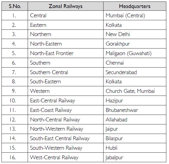
Map activity: Consult the table above and locate the points on the map.
Question 16:
Why is air travel preferred in the north-eastern states?
Answer:
The uneven and mountainous terrain of the north-eastern states makes it difficult to construct roads or railways. Hence, airways are preferred as just an airport has to be constructed.
Question 17:
Find out the names of the countries connected by Indian Airlines.
Answer:
The countries connected by Indian Airlines (now Air India) are: Europe, Iraq, Bangladesh, USA, Africa, Egypt, Malaysia, Australia, Italy, etc,. (Find out more from the internet.)